The key deliverable for Phase 1 will be a demonstration of the basic RRM workflow and prototype software environment.
Input Data (1)
A fundamental component of this deliverable involves the development of interactive software tools applying direct model manipulation approaches, such as Sketch-based Interface and Modeling (SBIM). These techniques allow intuitive, direct interpretation, manipulation and modeling of reservoir data by using sketches extracted directly from user input. The reservoir geometry will be created / edited with SBIM methods from the following input data:
- Surfaces imported from existing Petrel models; this will build on on-going work at ICL in which structured (Petrel-type) surfaces are converted to unstructured meshes whilst preserving surface intersections and other sharp features
- Reservoir geometry created from a blank screen; this functionality will allow conceptual models to be rapidly created and their reservoir behaviour investigated. Surfaces will have rules assigned to dictate how they interact; for example, they may erode earlier surfaces or be eroded by later surfaces, or conform with or on-lap earlier surfaces.
- Reservoir geometry created using template surfaces representing common geological architectures; a library of these surfaces (initially containing 3-4 shapes, with additional shapes added in later years, increasingly through a growing global user base) will be developed that can be used to rapidly create geological features with similar generic shapes (e.g. clinoforms). The surfaces can then be manipulated in step (2) to vary the initial template geometry. Users will also be able to create their own template surfaces.
- Global database and Wiki where geological scenarios can be collected, stored, and accessed for analysis and modification. Geological scenarios are often lost in conventional workflows, existing only in head or on paper; the RRM workflow will allow 3D conceptual models to be rapidly created and then stored for future use.
It is suggested to initially demonstrate and test the workflow using surfaces from a Petrel model donated by one of the industry partners.
Surface Extraction and Manipulation (2)
Petrel surfaces and the common geological structures (templates) or freely-sketched geometries can be modified using a set of SBIM operators for reservoir geoscience and engineering, currently being developed at UofC. Surface extraction applies to both sub-horizontal and sub-vertical surfaces, i.e. to sedimentary horizons and faults. The modified geometries, both from existing models and the newly generated surfaces, can be combined resulting in new reservoir geometry. Surfaces will be represented by adaptive mesh structures. The user will be able to sketch and model simple wells, represented as 3D curves. The software components will be developed initially for desktop-based computers with SBIM support for pen displays such as Cintiq.
Gridding (3)
As a first step, basic pillar-gridding technologies will be developed to automatically translate the modified surfaces from (2) into a numerical discretization suitable for flow and mechanical computations in (5) and straightforward export to commercial simulation and modeling software such as Petrel in (8). To aid both mechanical and flow calculations, the pillar grid will be translated into a corner-point grid with hexahedral finite elements and corresponding finite volumes. Later during Phase 1, the pillar grids will be translated into unstructured grids using 3D tetrahedral finite elements using the well-established and Open Source CGAL library, which is already heavily used in the oil and gas industry. This will allow us to start crucial research on overcoming well-known limitations of pillar grids to represent complex geological structures in a rapid reservoir modelling framework. At this stage, the 3D tetrahedral grids will be comparatively simple and not yet provide the full geometric flexibility that is associated with them; however, this work will build the foundation for implementing fully automated and adaptively refined 3D tehtrahedral gridding with mesh repair functionality in Phase 2. Gridding research builds on on-going research activities at HWU and UFPE in unstructured-grid reservoir and geomechanical simulation.
Characterisation (4)
A library of default property values (permeability, porosity, Young’s modulus, density etc.) for given rock types will be developed; initially, the values could come from a field dataset donated by the industry partners. The library will be expanded throughout the project; users will also be able to create their own rock types and associated properties through a dedicated Wiki that will be interfaced with the RRM software. The user will select volumes in the new reservoir geometry from (2) and (3) and assign rock types to these volumes, using SBIM methods to select regions, combined with drag and drop. It is noted that this is not a geostatistical approach. Instead, rock types and corresponding, single-value petrophysical properties are directly assigned to a geologic volume defined by the surfaces created in step (2). Geostatistical methods to populate petrophysical properties within the RRM framework could be added in a future phase of the project. However, interfacing RRM with commercial geo-modelling tools (e.g. Petrel, GoCAD-SKUA; see step 8) will allow the industry partners to export surface-based models constructed using all or part of the RRM workflow, and apply the geostatistical methods available in these commercial packages if they choose to do so.
Computation (5)
A suite of basic calculations of static reservoir properties and dynamic reservoir behavior will be available to demonstrate that numerical computations can be carried out automatically on the reservoir geometry, represented by volumetric finite elements/finite volumes in step (3), and populated with petrophysical properties in step (4). Many of these calculations are available in existing commercial modeling and simulation packages. However, our rapid reservoir modeling concept envisages direct feedback between modeling choices and calculations, which can only be achieved by integrating the calculations within the RRM workflow. Moreover, many of the existing commercial tools are limited to simple corner-point and/or unstructured but k-orthogonal grids, which are incompatible with the meshing of complex geometries that will be required in RRM. Until the integrated calculation tools become available in RRM, industry partners will be able to use the interface with commercial tools to make the calculations they require, subject to the limitations of those tools.
Calculations of static and dynamic reservoir properties will build on extensive experience in unstructured-grid reservoir simulation at HWU and ICL. There are several Open Source platforms available for this work, including Fluidity at Imperial College, or Dumux, which is a leading software framework for modeling single- and multi-phase flow processes in porous media. Dumux is also part of the industry-supported Open Porous Media initiative, which promotes the joint academic-industry development of Open Source software . Both Fluidity and Dumux already provide functionality for finite volume and finite elements on unstructured grids. Basing the research on Open Source software will allow us to make our numerical algorithms completely open and share any source code with the industry partners, so they are free to rewrite them, or incorporate them in commercial or proprietary software during and/or after the project.
The following basic calculations will be available at the end of phase one:
- Define surfaces for fluid contacts (oil water contact and gas oil contact) and compute fluid volumes in place.
- Compute the volume of fluid connected to a well based on one or more rock property thresholds (e.g. permeability, saturation). Volumes will be updated interactively as the threshold values are changed (for example, using a sliding bar). In phase 2, interactive calculations of connected volumes will be extended to assist well placement.
- Compute initial fluid pressure and geothermal gradient in the reservoir using finite element/finite volume techniques for unstructured grids.
- Compute initial over-burden and (effective) stress distribution using finite element techniques.
- Simulate the propagation of seismic waves in through the model geometry.
Exploratory Visual Analysis (6)
Using existing operators developed at UofC, the reservoir geometry, property distribution, and simulation results can be visualised on desktop computers and interactive display surfaces such as Microsoft Surface.
Scenarios (7)
The RRM prototype will be tested jointly with researchers from the industry partners on an annual basis to review its suitability and user-friendliness, and develop future modelling scenarios and visualisation techniques that should be incorporated in the RRM workflow. This may require reviewing and amending deliverables for phases 2 and 3 accordingly.
Output (8)
The modified reservoir geometry can be exported to Petrel for future use in conventional reservoir modelling and simulation workflows. Output will include (a) the surfaces defined at the end of step (3), converted to the structured format required by Petrel, and (b) corner-point grids and associated rock properties defined at the end of steps (3) and (4). Note that output to Petrel will be implemented early in Phase 1. This will allow industry partners to make use of the RRM workflow as it develops, with models developed in an early and incomplete RRM workflow available for export to conventional modeling tools and the functionality available in those tools.
Milestones
An overview of the timeline to achieve these milestones is given below.
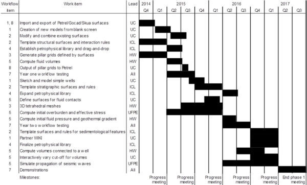
Timeline for phase 1. Each academic partner will take the lead in a given activity, but will collaborate closely with the other partners.
End year 1
- Import and export of Petrel surfaces, allowing users to leverage existing Petrel models and functionality
- Create new models from blank screen using SBIM
- Modify and combine existing surfaces using SBIM
- Create new structural models using SBIM, template geological surfaces and surface interaction rules
- Generate pillar grids defined by model surfaces
- Populate model volumes with basic petrophysical data from prototype library
- Compute fluid volumes
End year 2
- Sketch and model simple wells, represented as 3D curves
- Create new stratigraphic models using SBIM, template geological surfaces and surface interaction rules
- Expanded library of petrophysical data, including options for user-defined values
- Define surfaces for fluid contacts and use these in fluid volume calculations
- Generate 3D tetrahedral meshes based on the initial pillar grid
- Compute initial overburden and effective stress distribution
- Compute initial fluid pressure and geothermal gradient
End year 3
- Create new facies/rock type models using SBIM, template geological surfaces and surface interaction rules
- Establish sponsor/academic WIKI of models and template surfaces
- Compute volumes connected to well(s) with interactive cut-off values
- Simulate the propagation of seismic waves through the model volume
- Demonstration of the complete RRM workflow in a number of scenarios (to be identified with sponsors)